Blog Article List Home Contact Me
|
Wilkes: Ditch Creek, John Brooks,
Civil War, land grant August 23, 2019 At Home On Ditch Creek You never know where the
next interesting history tale might pop up.
Today’s journey takes us to the banks of Ditch Creek along Oklahoma Rd
near the Wilkes and Alleghany border. On page 51 of the book Log Cabin Families of Stone Mountain, NC,
a story is recounted by Annice Brooks Royall about her grandfather John Brooks. She said he hid out in a cave on the side
of a mountain to keep from going to the Civil War. “At that time he and his
wife had at least six living children, Annice’s father, William, the oldest
child, being no more than 12 years old.
By following his dog the Home Guard found John Brooks and shot
him. He died that night and is buried on
a ridge of land bought from Bob Bryan.
Though his grave is not evident, a patch of periwinkle under the trees
gives the location (1960).” John Brooks was my
uncle. I descend from his sister
Lucinda Brooks Pruitt (1833-1899).
They were both children of Zachariah Brooks and Sarah Bauguess. So exactly where did this Brooks
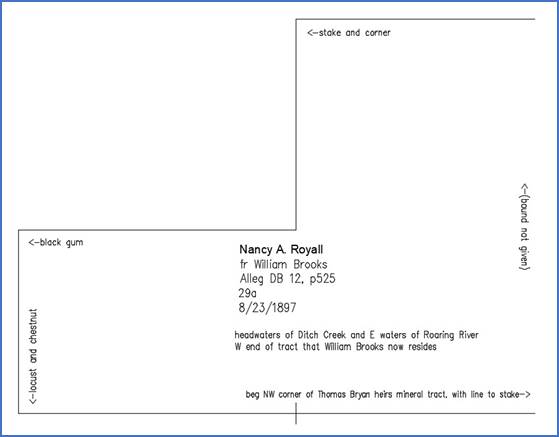
family live? Below is a deed from
William Brooks, John’s son, to his daughter Nancy Annice Brooks Royall
(1879-1958). Annice is the one who recounted
the story.
Annice received 29 acres on
the west end of her father’s land in 1897 according to Alleghany DB 12, p525. The land was at the headwaters of Ditch
Creek. I wonder if any locals know the
creek by that name today? Below is an earlier deed
from Wilkes County is from Robert C. Bryan to John Brooks (DB C2, p336).
This deed is dated 2/17/1872
which is well after the Civil War. So it
appears that John Brooks somehow bough this land after he was killed by the Home
Guard. The deed was proven in Wilkes
Probate Court in 1876. My guess is
that Robert Bryan informally sold this land to John Brooks during the war, but
that the actual deed wasn’t made until 1872.
The fact that it was proven in Probate Court suggests (to me) that one
of the parties was deceased. Sometime after 1872, John’s
son William bought or inherited this land, and in 1897 he sold the western
third to his daughter Annice. In
Annice’s story, she said the land had been bought from Bob Bryan, and that
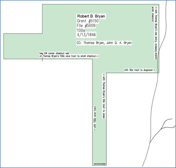
must be this 1872 deed. The original land grant was
to Robert B. Bryan in 1846 for 100 acres.
The grant includes 13 more acres than the 1872 tract, and that extra
portion extends to the south.
The northern edge of this
grant was located a quarter mile south of present day Liberty Knob Church on Oklahoma
Rd. This is the road that goes up the
mountain from Elk Spur Church near Stone Mountain to Highway 21 at Roaring Gap. The southern portion of the tract is just
inside Wilkes County. This is in tile B4 on my map
of grants on Roaring River. Ditch
Creek runs just behind Elk Spur Church and all the way along Oklahoma Rd to its
headwaters just below Liberty Knob Church.
The creek on the east side of the grant (shown with the black curving
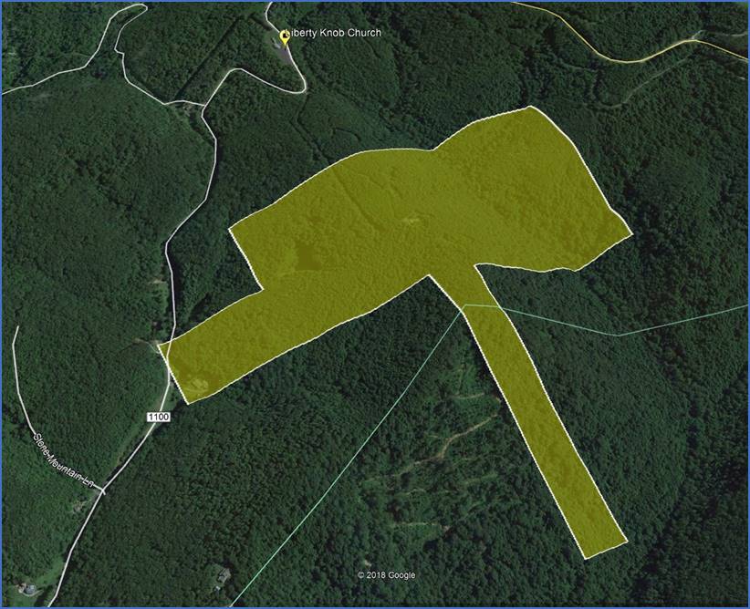
line) is the head of Sparks Creek. This is the same grant that
I sketched in Google Earth. It just
crosses Oklahoma Rd on the west. If
the grant is in the shape of a hammer, then the handle extends south beyond
the county line at Stony Knob.
Annice said that her
grandfather was buried “on a ridge of land bought from Bob Bryan”. Notice the ridge that runs from Liberty
Knob Church south through the middle of the grant. My guess is that this is the ridge where
John Brooks was buried during the Civil War. Annice knew where the location was in 1960,
marked by a growth of periwinkle. I
wonder if anyone knows the location today. This is a perfect example of
how mapping these original land grants can help with genealogy. Now I have a good idea of where my uncle’s
family lived and where he was buried.
Comments? jason@webjmd.com |